Along with chocolate frosted donuts at the local pool (a treat after swim lessons), road trips were the defining events of my childhood summers. My mother was not a fan of airplanes and so every August we would pile into the car before dawn on a Saturday and head out across the country.
The night before departure had its own exciting rituals: my brother and I would take our suitcases out to the car (my father, the master of vehicular geometry, packed the trunk), tuck magazines and games and puzzle books and Mad Libs into the seat pockets, and make sure we had our favorite pillows ready to go. The next morning, our parents would wake us up in darkness (though truthfully, we were almost always already awake—it was like a different kind of Christmas on those hot summer mornings) and we hit the road before the sun came up.
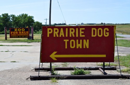
We lived in Colorado, so we had abundant options. When we went east, we took Interstate 25 to 225 to 70 and then the choice: Kansas or Nebraska? If our route took us through Kansas we always stopped near the border for breakfast, and then at Prairie Dog Town in Oakley, my brother and I giggling over the six-legged cow and the World’s Largest Prairie Dog before blowing some of our trip money on plastic wallets with “Indian” designs or plush animals that lost their eyes a week later.
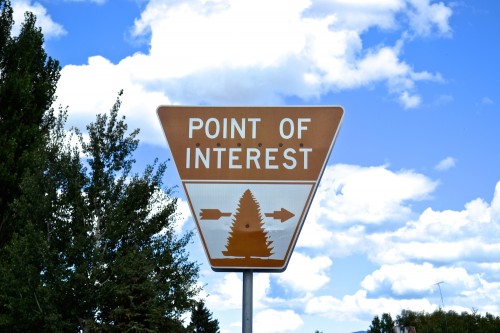
All of these trips—no matter the direction—took us to state and national historic sites, museums, amusement parks, and the streets of cities and towns. We stayed at Best Westerns and Holiday Inns (my parents quickly wearying of our insistent and incessant question—“does it have a pool?”) and ate mostly at fast-food restaurants and diners. Although at least once we would stay in a fancy hotel (the Williamsburg Inn in Virginia, for example, or Chateau Lake Louise in Alberta, Canada) and eat dinner at a four-star restaurant. Such experiences, my parents thought, would teach us manners.
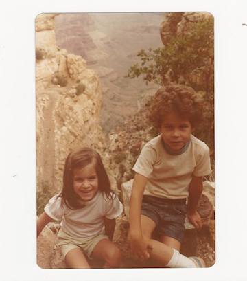
As we crossed the country my brother and I burrowed into our nooks in backseat; every now and again, though, one of us would be called up to the front.
For me, this was always a highlight. It meant that I had an unobstructed view of the landscape. Although I was often reading or playing games in the backseat, I also rested my head against the glass and watched the grass and cows and towns and trains and city streets go by. It was during these car trips that I developed my love of looking at the world around me–this probably explains why I became an environmental historian.
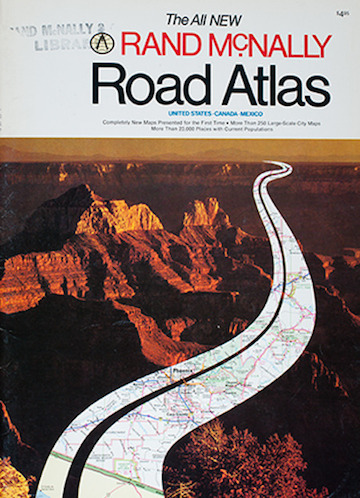
It was also exciting to go up front because in the passenger seat, I was The Navigator. I loved to look for road and exit signs, and match these up to Rand-McNally’s lines and dots. It was a heady responsibility; I would inform my father or mother of our current location and how far we had to go to our destination, or point out a town that could provide an opportunity for stretching and snacks. I did this with all the grave seriousness an eight-year-old girl could muster.
It was also on these trips that I came to travel through and see—really see—43 of the 48 continental United States, and much of southern Canada by the time I was in high school. We never went to the Deep South, mostly because the summer temperatures and humidity argued against it. This might also explain my fascination with that region in college and graduate school—these were places I had never seen, histories I had never encountered before.
So when I set out on my research road trip this past August, I carried all of these memories with me, in addition to a rather excessive number of bags. I packed the car the night before (aspiring but not quite reaching the geometric perfection my father had modeled for me), woke up in darkness, made sure I had my box of books (for reading while not driving, obviously) and my snacks. I did not bring my pillow—one of my major regrets.
This time, however, I was going it alone. I was my own Navigator, which necessitated a lot of preparatory research and constant use of my iPhone mapping system—and created a crisis when my iPhone suddenly died in the middle of a New Mexico desert. I was able to revive it a few hours later and the burner phone I had purchased in a panic went mostly unused for the rest of the trip. I had not been aware of my total reliance on my communications and mapping technologies before this point—I was hyper-aware of it afterwards.
We have satellite radio in my car, so I was assured of the company that alternative rock musicians and NPR hosts provide. And (as I noted in a previous post) I had friends and family along the way, who knew I was coming and welcomed me to their towns and cities. I spent fruitful days in the archives and even more productive days out in the landscape, taking my car off-road and setting out by myself on walks and hikes. For more on what I found both inside and outside, head over to JSTOR Daily and my column, (Un)Catalogued.
As I drove and walked around, and veered suddenly over to the side of the road to check out historical markers, I was able to combine my love of archival research and my even longer-standing love of looking around. For my colleagues in academia who can take the time away to embark on such an adventure, I highly recommend it. And for my friends who are planning family vacations, I can tell you that piling the kids into the car, turning off the electronics (except the mapping function, of course), and spending some time just gazing out of windows is an experience that will remain vivid in their kids’ memories, and in their imaginations.
2014 RESEARCH ROAD TRIP STATS:
Miles driven: around 7,100
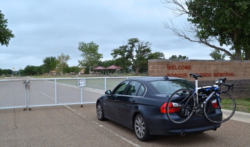
State and National Parks and Historic Sites visited: 15 The only site I attempted to see but failed to see was Bosque Redondo Memorial in Fort Sumter, New Mexico. The website says it is open on Mondays. It is not open on Mondays.
Number of times I crossed the Continental Divide: 4
Number of speeding tickets: 0 A miracle
Number of parking tickets: 1 Also a miracle
Miles biked: around 240 Not enough to counteract all of the delicious but insanely rich food I was eating. See below.
Wheels replaced on the bike: 2
Border Patrol checkpoints: 5 Need to smuggle anything through the desert? Give it to a white woman in a nice car.
Libraries and archives visited: 10
Pages of notes (typed) in the aforementioned archives: 360
Photographs taken: 1,982
Regional food specialties sampled: 5 This number seems low, perhaps because I usually sampled them more than once
- Green Chile Enchiladas (Santa Fe, New Mexico)
- Fry Bread (Navajo Nation, Arizona)
- Sonoran Hot Dogs (Tucson, Arizona)
- Salt Lick Brisket (Driftwood, Texas)
- Buffalo Wings (Buffalo, New York)
Margaritas quaffed: too many to count This is no surprise to anyone, is it?
Dang it – forgot to ask a question. Did you happen to bicycle over Monarch Pass?
I was fortunate enough many decades ago to go on a supported bike tour of Colorado from the Southwest corner all the way to Boulder with an excursion through Rocky Mountain Nat’l Park. We were riding Cat 5 climbs before anybody knew what they were.
Nice post. Our family summer vacations weren’t pre-dawn endeavors. Dad would say “Doris, will you be ready to leave at 8AM?” To which my mother replied “yes” – with everyone knowing that it would be at least 9AM before the car left the driveway — Mom always had to properly dress and accessorize – even for a day in the car.
Gotta love the Rand McNally — even when we head out on a familiar path, I always stash the atlas in the back seat. Did you ever pick one the red highways in the atlas (US1, US40, etc) and follow it from end-to-end in the atlas? Great way to learn about the US and how cities, states are connected together.
But, of course, the most important thing, was being the Navigator.
I had a Rand McNally (from 2009, but still) with me for this trip too, as backup. I used it once or twice, just to get the big picture (as you note) when expanding the image on my phone became too annoying.
And sadly, we did not bike Monarch Pass or any other pass. The elevation really kicked us in the teeth in Colorado–but in Aspen we did ride to Aschroft ghost town and to Maroon Bells (both those rides are about 20-22 miles roundtrip, 1500+ feet of elevation gain). My rides in Santa Fe and Marfa had some hills, but I believe my rides in Albuquerque and Mesilla had a sum total of 32 feet of elevation gained. That’s some flat riding, man.